Custom Topo Maps and Aerial Photos for Hunters
NEW
- GMU Boundary overlay option on all of our custom map options.
- Private Land Boundary option: Extra charge
- Overlay US Forest Service Roads on maps from 95 National Forests in the Western U. Maps depict whether the roads are closed, 4-wheel drive only, suitable for passenger cars on non-Forest Service managed.
- Public Land boundaries to identify USFS, BLM, US Nat’l Park, or state and grasslands areas.
- Option to overlay 132,000 miles of snowmobile trails in 27 states.
- USGS quads (by the quad or customized)
- Eastern US Public Lands maps pre-centered on 28,593 public lands, WMA’s, state lands, forests, and parks in 34 Eastern states.
- APP for iPhone, iPad, and Android platforms
|
Custom Topographical Maps & Aerial Photos
CLICK HERE TO START Your One-Stop Resource is Right Here
|

Topo Map / Aerial Photo (click)
|
 Aerial Photos (click)
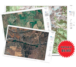
We receive thousands of E-mails and calls from hunters from every corner of the country asking where they can find quality topographical maps of their favorite elk hunting spot. Now via our partnership with MyTopo.com you have an online one-stop resource for all of your topographical map and aerial photography needs. Just click on one of the links or images on this page to begin creating your own custom Topo map or aerial photograph of exactly the area you are researching or planning to hunt.
You can choose from waterproof or glossy in three sizes up to a huge 36" by 44" wall map! Custom Topos start at only $9.95 and aerial photos at only $14.95.
By purchasing your Topo maps and aerial photos via our ElkCamp.com website, you will help us to continue to make ElkCamp.com a better resource for you and your fellow elk hunters in the future. Thanks for your faithful support! Tell your friends.
You precisely center your custom map anywhere in the US. This solves one of the biggest problems with stock maps... having to buy two, four, or more maps to cover the area you want. Every one of our maps is made from the most detailed and most current USGS maps available. We print every map on special high-quality equipment to produce a beautiful, detailed map.
The customization doesn’t end there. Each map is available in a variety of sizes from 18” by 24” to a huge 36” x 48”. We offer the maps in a variety of finishes including waterproof synthetic papers, glossy poster products, and full-seal laminated maps. Every map is printed with UV/fade-resistant inks designed to last through the harshest tests for years to come.
Since you design every map, you can add your own titles, your name, and GPS navigational grids for every map. And we didn’t forget the details that make a quality map product. All of our maps are scaled precisely for accurate measurement and use with navigation tools and include detailed scale bars and north arrow diagrams with current declination.
Finding the right map can be a hassle, but when you design and buy your map from ElkCamp.com and MyTopo.com you will have it in your hands fast! Every map is shipped within 24 hours and we offer a variety of shipping options up through next-day service.

Look for our Logo on your MyTopo map to ensure that you have a genuine ElkCamp.com map or aerial photo